
May 30,2022
300 Maps of Everything You Can Think Of
by David Stewart
Three hundred maps are presented in the new book Map: Exploring the World (Phaidon, $60), and nearly all qualify as works of art. But look closer and you’ll see even more. Spanning thousands of years and selected by a team of curators and collectors, these maps serve as both historical records and cultural snapshots, communicating complex ideas about geography, politics, science, and more in a single image—be it an eighth-century chart of the stars or a 1930s guide to the stars’ Hollywood homes.
Map includes works from cartography greats as well as from artists and writers such as Ai Weiwei, Jack Kerouac, Robert Louis Stevenson, Jasper Johns, and Maya Lin. The various entries will help you—often in a glance—understand the landscape of early Europe, the arrondissements of Paris, the flight patterns of planes and birds, the global density of tweet activity, and the mind-set of New Yorkers. This is a big, beautiful book of wonder.
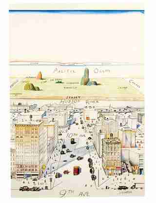
View of the World from 9th Avenue, 1976
This famous map, created by artist Saul Steinberg for the cover of The New Yorker, highlights the myopic worldview of Manhattanites. It’s a humorous depiction of self-absorption, and a modern classic.
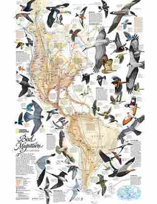
Bird Migration in the Americas, 1979
This map, originally published in National Geographic, spotlights the migratory routes of 67 bird species in the Western Hemisphere, linking their nesting grounds and wintering areas. The birds were painted by wildlife artist Arthur Singer.

Mapping the Brain, 2014
Using a type of magnetic resonance imaging, the Human Connectome Project created this digital image, which looks like modern art but actually maps the neural pathways that underlie brain function.
A Map of Vesuvius, 1832
This lithograph by 19th-century geologist John Auldjo is a record of the volcanic activity of Italy’s Mount Vesuvius between 1631 and 1831. The colored flows show the direction and scope of 27 separate eruptions.
Hurricane Katrina Flooding Estimated Depths and Extent, 2005
A more recent natural disaster is captured in this enhanced satellite image, prepared by NOAA and FEMA, illustrating the estimated depth of the floodwaters across New Orleans five days after Hurricane Katrina struck the city. The areas shown in yellow and green are under five to ten feet of water.
Serio-Comic War Map for the Year 1877, 1877
This war map by English draftsman and illustrator Frederick W. Rose portrays Russia as a giant octopus whose tentacles are ensnaring Poland, pulling at Turkey, and choking Persia, while Germany pushes back. Though comical, the drawing attempts to explain complicated geopolitical rivalries.
Australia, 2012
This playful hand-drawn map of Australia by graphic designers Aleksandra Mizielinska and Daniel Mizielinski is intended for younger audiences, and it spotlights exactly what most kids want to know about a country: its unique animals and weird foods.
Death to Fascism, 1941
Here, map as propaganda. When Germany broke its nonaggression pact with the Soviet Union in 1941 by invading the country, the state needed to generate support for the sudden, unexpected war. In this image by a trio of Soviet artists, the monstrous mustachioed German enemy—leaving a trail of paw prints across Europe—is met by the proud bayonets of the Red Army.
Map: Exploring the World
The new book is now available from Phaidon.